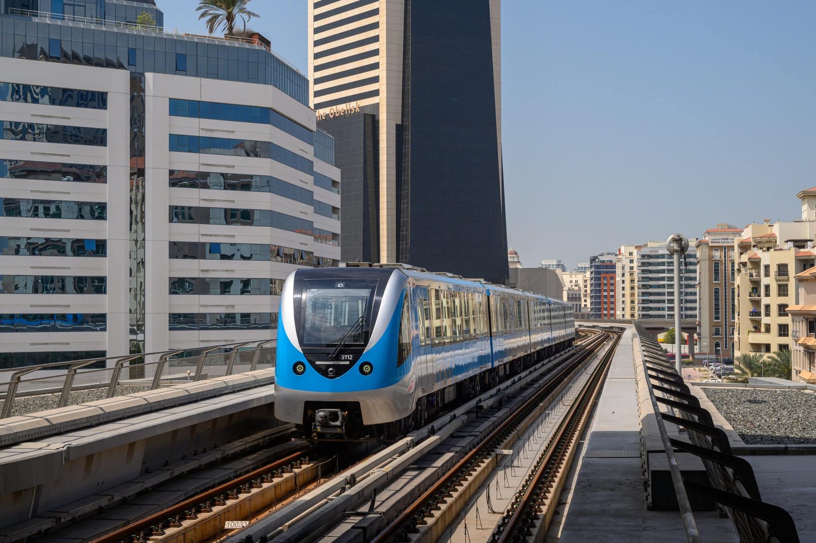
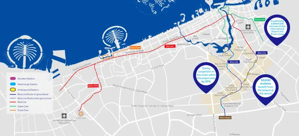
Dubai’s urban landscape is set for a monumental shift with the Dubai Metro Blue Line, launching on 9 September 2029 — the 20th anniversary of Dubai Metro. This mega-project promises to revolutionise commutes, slashing travel times and cutting city-wide traffic congestion by 20 percent. It will directly connect nine key areas, including Dubai International Airport (DXB), to the existing Metro network.
His Highness Sheikh Mohammed bin Rashid Al Maktoum, Vice President and Prime Minister of the UAE and Ruler of Dubai, officially launched primary tunnelling works on May 3, affirming the ambitious timeline. The Roads and Transport Authority (RTA) projects the Blue Line will serve approximately one million people,Key fact Detail Total stations 14 new stations Total length 30km (21km + 9km across two routes) Underground section 15.5km Opening date 9 September 2029 (Dubai Metro’s 20th anniversary) Connects to Dubai International Airport (DXB), existing Red & Green Lines Projected daily riders ~1 million Iconic/interchange stations Emaar Properties Station (Dubai Creek Harbour), International City 1 (44,000 sqm, up to 350,000 passengers/day)
The project features two distinct routes: a 21km stretch and a shorter 9km segment, with 15.5km running underground. This expansion is designed to ease existing traffic pressure and enhance connectivity across vital residential, academic, and commercial hubs.
Connecting the City: The 14 New Stations
The Blue Line will introduce 14 new stations, integrating seamlessly with the existing Red and Green Lines. Key areas served include:
- Academic City: A new station will drastically cut commute times for over 50,000 students and faculty, especially during the summer.
- Al Jaddaf: The first route commences at the existing Creek Station, offering a direct Green Line interchange.
- Al Rashidiya: The second route starts here, serving as a crucial interchange with the Red Line’s Centrepoint Station.
- Al Warqa: This residential area, home to 60,000 residents and Dubai Safari Park, gains a much-needed direct transport link.
- Dubai Creek Harbour: Home to the Emaar Properties Station, set to be the world’s tallest Metro station at 74 metres, designed by Skidmore, Owings & Merrill (SOM). Spanning 11,000 square metres, it will handle up to 160,000 passengers, with over 70,000 daily users. A 1,300-metre viaduct will cross Dubai Creek.
- Dubai Festival City: This hub, with one of the city’s largest malls and 77,000 residents, gets a direct link, reducing reliance on abra services.
- Dubai International Airport (DXB): A crucial direct link will connect DXB to key areas in just 20 minutes, replacing AED 40-50 taxi fares with Metro journeys under AED 10.
- Dubai Silicon Oasis: A station on the 21km route will support this growing technology and innovation hub.
- International City: Three new stations, including International City 1 — the network’s largest underground interchange at 44,000 sqm with capacity for up to 350,000 passengers per day. This mega-hub will significantly boost connectivity for its 200,000+ residents and Dragon Mart visitors.
- Mirdif: The 21km route extends to this popular suburban community, enhancing access to Al Mushrif Park and City Centre Mirdif.
- Ras Al Khor: Positioned between Emaar Properties Station and International City, this area, known for its wildlife sanctuary, gains greater connectivity.
Transforming Urban Mobility and Lifestyle
The Blue Line is a strategic intervention to fundamentally transform urban mobility and enhance quality of life. The projected 20 percent reduction in city-wide traffic congestion is a monumental benefit. Direct connectivity to DXB for nine key areas will drastically improve efficiency for residents and tourists, making Dubai even more accessible as a global hub.
Beyond transport, the Blue Line will reshape daily life and influence the property market. Enhanced connectivity boosts desirability, increasing property values and demand in newly served areas like Academic City, Al Warqa, and Mirdif. Iconic stations, such as the Emaar Properties Station at Dubai Creek Harbour, will become architectural landmarks, enriching the urban experience.
For UAE residents, this means significantly improved connectivity, especially to previously underserved areas and DXB. It will streamline access to major attractions like Dubai Festival City Mall, Dragon Mart, and Dubai Safari Park. The expansion into residential hubs like International City and Mirdif offers more affordable and efficient commutes for budget-conscious expat communities. While specific fare structures are pending RTA announcements, integration with the existing Nol card system is expected, maintaining affordability.
The Dubai Metro Blue Line is a cornerstone of Dubai’s ambitious 2040 Urban Master Plan, reflecting the city’s commitment to sustainable transport and smart infrastructure. It ensures a world-class public transport network that supports Dubai’s vision as a leading global city well into the future.
Dubai Metro Blue Line: Route 1 vs Route 2
The Blue Line operates on two interconnected routes. Both plug into the existing Red and Green Lines at interchange stations, so a single Nol card covers the entire network.
| Route | Distance | Start | End | Key Stations |
|---|---|---|---|---|
| Route 1 | 21km | Al Jaddaf (Green Line interchange) | Mirdif | Dubai Creek Harbour, Dubai Festival City, Dubai International Airport, Ras Al Khor, International City (3 stations) |
| Route 2 | 9km | Al Rashidiya (Red Line interchange) | Dubai Silicon Oasis | Academic City, Al Warqa |
Both routes share a 1,300-metre viaduct across Dubai Creek. Of the total 30km, 15.5km runs underground — covering the densest urban sections — with the remainder elevated.
What the Blue Line Means for Your Commute
For residents currently relying on taxis or buses, the Blue Line introduces direct metro access with measurable time and cost savings:
- DXB to Academic City: A 35–50 minute drive at peak hour drops to roughly 20–25 minutes by metro — no parking costs, no congestion.
- International City to DIFC: Three Blue Line stations serve International City; passengers connect via Green Line to DIFC, replacing a slow bus-dependent route.
- Mirdif to the airport: Mirdif gets its first direct metro link, ending reliance on feeder buses for the area’s large expat population.
- Al Rashidiya to Silicon Oasis: Route 2 creates a direct tech corridor for employees in Dubai Silicon Oasis and students at Academic City (50,000+ people).
The Blue Line uses the same Nol card system as the Red and Green Lines — no new card needed. Your existing Silver, Gold, or Blue Nol card works across all three lines from day one.
Construction Timeline
| Milestone | Date | Status |
|---|---|---|
| Contract award and project announcement | 2023 | ✅ Complete |
| Primary tunnelling launched by HH Sheikh Mohammed | 3 May 2026 | ✅ Complete |
| Major underground construction (15.5km) | 2026–2028 | 🔄 In progress |
| Station fit-out and systems integration | 2028–2029 | ⏳ Upcoming |
| Blue Line opening | 2029 | ⏳ Target |
Dubai Metro Gold Line: What We Know
Announced on 22 April 2026, the Dubai Metro Gold Line is the next confirmed phase of Dubai’s metro expansion after the Blue Line. Spanning 42km with 18 stations — all underground — it will push the network even deeper into the city’s growing districts. The target opening date is 9 September 2032, maintaining the now-traditional 9 September milestone pattern.
| Gold Line Stat | Detail |
|---|---|
| Announcement date | 22 April 2026 |
| Total length | 42km |
| Stations | 18 |
| Underground throughout? | Yes |
| Planned opening | 9 September 2032 |
| Investment | TBA |
Dubai Metro Blue Line FAQ
When does the Dubai Metro Blue Line open?
The Dubai Metro Blue Line opens on 9 September 2029 — specifically chosen to mark the 20th anniversary of Dubai Metro (which first opened 9 September 2009). Tunnelling works were officially launched on 3 May 2026 by His Highness Sheikh Mohammed bin Rashid Al Maktoum. Construction was at 10% completion by November 2025, targeting 30% by end of 2026.
How many stations does the Blue Line have?
14 new stations across both routes — nine on Route 1 (Al Jaddaf to Mirdif) and five on Route 2 (Al Rashidiya to Dubai Silicon Oasis / Academic City).
Do I need a new Nol card for the Blue Line?
No. The Blue Line integrates fully with the existing Nol card system. Your current Silver, Gold, or Blue Nol card will work across all three metro lines from opening day. For a full guide on Nol card types, top-up options, and registration, see our Nol card guide.
Is the Blue Line underground or elevated?
Both. Of the total 30km, 15.5km runs underground (through the denser urban sections); the remainder is elevated. The Dubai Creek crossing uses a 1,300-metre viaduct.
How does the Blue Line compare to the Red and Green Lines?
The Red Line (52.1km) is the network backbone, running from Rashidiya through DIFC, Mall of the Emirates, and out to Dubai Marina. The Green Line (22.5km) covers Bur Dubai, Deira, and Healthcare City. The Blue Line (30km combined) extends coverage east and south into previously underserved communities — International City, Mirdif, Academic City, and Al Warqa — while adding a faster direct DXB link for nine key areas.